↓
 

Greenville Land Surveying

Local Land Surveyors in Greenville, SC

Greenville Land Surveying
  • Home
  • ALTA Survey
  • Boundary Surveying
  • Construction Survey
  • Drone LiDAR Mapping
  • Elevation Certificate
  • Land Surveying
  • Topographic Survey
  • Blog
  • Contact Us
Home 1 2 3 … 6 7 >>

Post navigation

← Older posts

Welcome to Greenville Land Surveying

Greenville Land Surveying Posted on August 18, 2017 by GreenvilleSurveyorApril 15, 2020

Your Final Stop for ALL of Your Survey Needs!                                         Contact us today for a free quote!

This site is intended to provide you with information on Land Surveying in the Greenville, SC and Greenville area of South Carolina. If you’re looking for a Greenville Land Surveyor, you’ve come to the right place. If you’d rather talk to someone about your land surveying needs, please call our local number at (864) 477-4944 today. For more information, please continue to read.

land surveyingLand Surveyors are professionals who make precise measurements to determine the size and boundaries of a piece of real estate.  While this is a simplistic definition, boundary surveying is one of the most common types of surveying related to home and land owners. If you fall into the following categories, please click on the appropriate link for more information on that subject:

Greenville Land Surveying services:

    1. I need to know where my property corners or property lines are. (Boundary Survey)
    2. I have a loan closing or re-finance coming up on my home in a subdivision. (Lot Survey)
    3. I need a map of my property with contour lines to show elevation differences for my architect or engineer. (Topo Survey)
    4. I’ve just been told I’m in a flood zone or I’ve been told I need an elevation certificate in order to obtain flood insurance or prove I don’t need it. (Flood Survey)
    5. I’m purchasing a lot/house in a recorded subdivision. (Lot Survey – See Boundary Survey if you’re not in a subdivision.)
    6. I’m purchasing a larger tract of land, acreage, that hasn’t been subdivided in the past. (Boundary Survey)

Contact Greenville Land Surveying services TODAY at (864) 477-4944.

Posted in boundary surveying, elevation certificate, land surveying, land surveyor | Tagged boundary survey, Greenville Land Surveying, land surveyor, land surveyor greenville sc

As-Built Survey: The Record of What Was Actually Built

Greenville Land Surveying Posted on May 29, 2026 by GreenvilleSurveyorMay 27, 2026
Surveyor reviewing site plans and utility layouts at a completed construction project for an as-built survey

An as-built survey is a record made after construction that shows exactly what was built and where. A surveyor measures the finished structures, utilities, and features on site, then compares them to the original plans. Contractors, owners, and local officials use it to confirm the work was done correctly and to close out permits.

Construction rarely follows the plan to the letter. Walls shift a few inches, pipes get rerouted, and surprises in the ground force changes on the spot. When the work is done, the blueprints pinned to the wall almost never match what truly stands on the site. An as-built survey fixes that gap. It captures the real, finished result so everyone has an accurate record. 

What Does an As-Built Survey Record?

An as-built survey documents a project in its completed state. Instead of showing what was planned, it shows what actually exists. A licensed surveyor visits the site after the work is finished and measures the real positions and sizes of everything that was built.

The survey typically records:

  • The exact location and size of buildings and other structures.
  • Utilities such as water lines, sewer pipes, and electrical runs.
  • Pavement, driveways, and parking areas.
  • How all of these sit in relation to the property and to each other.

The surveyor then produces a scaled drawing, sometimes called a plat, that lays out these details clearly. The final product can be a marked-up set of the original plans with the changes drawn in, or a digital file the design team can reuse.

How Is It Different From the Original Plans?

This is the heart of an as-built survey, so it is worth being clear. The original construction plans show what the team intended to build before any work started. An as-built survey shows what the team finished, measured in the field after the dust settled.

The two often differ. A pipe might be moved to avoid rock, or a foundation might shift slightly to fit the actual ground. Those field changes are real, but they only become part of the permanent record once a surveyor measures and documents them. The as-built survey turns the loose changes made during the job into one trusted, final record.

Why Do Contractors Order As-Built Surveys?

Contractors and project managers depend on these surveys for several practical reasons.

To Prove the Work Was Done Correctly

An as-built survey gives an official record of what was constructed. It lets everyone compare the finished site against the original design and confirm the work matches what was promised. This keeps owners, engineers, and inspectors aligned on the real result, not the intentions.

To Close Permits and Pass Inspections

Local governments often require an as-built survey before they will sign off on a project. It shows the work meets local codes and zoning rules. In many cases, this survey is a required step to close out a permit and to receive a certificate of occupancy, the document that says a building is legally ready to use.

To Capture Hidden Work Before It Disappears

Some parts of a project get covered up fast, and the chance to record them is short. Underground pipes are the classic example. A sewer line sits in a trench that will soon be filled and packed with soil. A surveyor can record the pipe’s exact position before the trench is closed, so its location is never lost.

To Satisfy Lenders on Funded Projects

On projects backed by a loan, the lender may want proof that the money is paying for the work as planned. An as-built survey verifies that the funded improvements are being built correctly, which protects everyone’s investment.

Who Else Relies on These Surveys?

The value of an as-built survey reaches well beyond the contractor. Several groups use it:

  • Property owners who want a true record of what sits on their land.
  • Architects and engineers who need accurate data for future design work.
  • Inspectors and local officials who confirm the project meets the rules.
  • Facility managers who handle repairs, maintenance, and upgrades later on.

Each group gets the same benefit: one shared, accurate picture of reality that they can all trust.

When Do You Need One?

You need an as-built survey at the point where you must prove what was built. The most common moments are:

  • At the end of a project, to close permits and earn a certificate of occupancy.
  • At key milestones on large jobs, so no important change goes unrecorded along the way.
  • Before a trench or wall is covered, to capture hidden utilities while they are still visible.
  • Before a future renovation or addition, the new design starts from an accurate record of what already exists.

On smaller projects, a single survey at the finish line is often enough. On large or public works, surveyors may update the record at several stages. Your contract, your local rules, or your lender usually sets the schedule.

The Lasting Value of an Accurate Record

An as-built survey does more than close out today’s project. It becomes the final, recognized version of what stands on the site, long after the crews have left. Future owners, design teams, and repair crews can rely on it to know exactly where things are. When an emergency crew needs to dig, an accurate record shows them where to work and what to avoid.

That long life is why the survey is worth doing well. A clear record now prevents guesswork, delays, and costly mistakes for years to come.

Posted in land surveying | Tagged Land Surveying

Topographic Survey: What It Shows and Why It Matters

Greenville Land Surveying Posted on May 28, 2026 by GreenvilleSurveyorMay 27, 2026
Surveyor using a total station on a construction site with contour lines showing elevation changes and topographic survey mapping

A topographic survey maps the shape of the land. It records the ground’s height, slopes, and surface features like trees, streams, and existing buildings. Builders, engineers, and architects use it to design projects that fit the land and drain water the right way. You need one before most construction, grading, or major landscaping work.

When you build on a piece of land, the shape of the ground matters as much as where the lines fall. A flat lot and a steep lot call for very different plans. A topographic survey gives your design team a clear picture of that shape before any dirt is moved. 

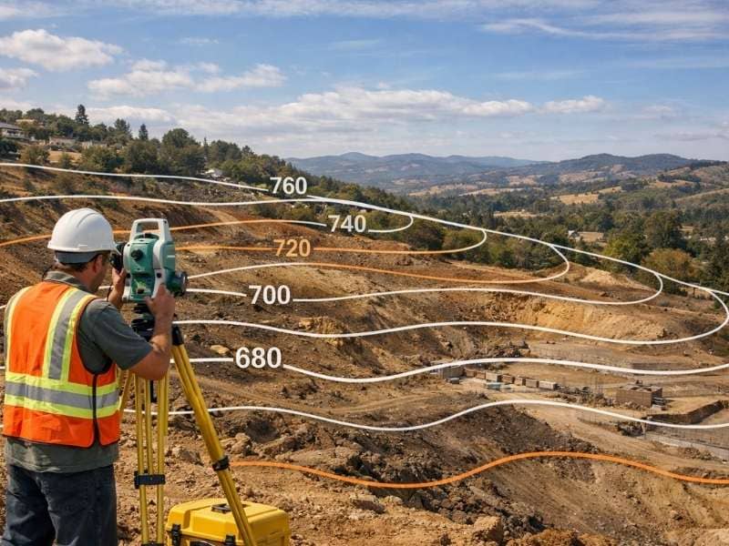
What Does a Topographic Survey Show?

A topographic survey, often called a “topo,” focuses on the up-and-down shape of the land rather than the property lines. It captures both natural and man-made features, including slopes, hills, dips, trees, streams, fences, and existing structures. The result is a detailed map that shows what the surface really looks like.

The key feature on this map is the contour line. A contour line connects points that sit at the same height above a fixed reference level, which usually mean sea level. If you walked along a single contour line in real life, you would stay at the same height the whole way, never going up or down.

Reading these lines is simpler than it looks once you know the basic rules:

  • Lines that sit close together show a steep slope, because the height changes fast over a short distance.
  • Lines that spread far apart show a gentle slope or flat ground.
  • Roughly circular lines usually show a hill or a peak.
  • Lines never cross each other, except in rare cases like an overhanging cliff.

The space between each line is called the contour interval, and it stays the same across the whole map. Common intervals are 1, 5, 10, or 20 feet, and the value is listed in the map legend. To make reading easier, every fifth line is often drawn thicker and labeled with its height. These are called index contours.

How Do Surveyors Create One?

A licensed surveyor collects height and feature data across the whole site, then turns it into a map. To gather that data accurately, surveyors use a mix of tools:

  • GPS units that pin down precise positions using satellites.
  • Total stations, which measure angles and distances on the ground.
  • Drones, which photograph the site from above to capture large areas quickly.

After the fieldwork, the data points are processed into the contour lines and labels you see on the finished map. Modern software can even build a 3D model of the site, so engineers can test ideas and spot problems before construction starts.

Who Uses a Topographic Survey?

Several groups rely on this survey, each for a different reason:

  • Homeowners planning to build, add on, or reshape their land.
  • Architects who want to design a home that sits naturally on the slope.
  • Engineers who plan roads, utilities, and water flow.
  • Contractors who prepare the site for grading and foundations.

Each of these professionals needs to know the true shape of the ground before they commit to a plan. Designing without it is mostly guesswork, and guesswork on a building site gets expensive fast.

When Do You Need a Topographic Survey?

You should order a topographic survey before most projects that change the land or sit on top of it. Here are the most common reasons.

Before You Build or Add On

Before any construction begins, your design team needs to understand the existing ground. The survey shows slopes, low spots, and existing features, so the building can be placed where it fits best. This is true for a new home, a large addition, or a commercial site.

To Plan Drainage and Grading

Water is one of the biggest concerns on any site. Because water always flows downhill, the elevation data shows your team exactly where it will go. They can then grade the land and plan drainage to keep water away from the foundation and prevent pooling or erosion. Getting this right early prevents serious damage later.

To Get Permits Approved

Many local governments require elevation and slope data as part of a permit application. The survey provides the proof that your project meets local rules for grading, stormwater, and drainage. Without it, your permit can be delayed or even rejected.

To Estimate Costs and Avoid Surprises

The amount of earth that must be moved depends on the real shape of the land. With accurate elevation data, your team can balance the soil that is cut away against the soil that is filled in. This leads to better cost estimates, less wasted material, and fewer expensive surprises once work begins.

How Is This Different From a Boundary Survey?

People often mix up these two surveys, but they answer different questions. A boundary survey answers “where are my property lines?” A topographic survey answers “what is the shape of my land?” One deals with legal limits, and the other deals with the physical surface.

Many building projects need both. The boundary work sets the legal edges of the lot, while the topographic work maps the terrain inside those edges. When you talk to a surveyor, you can ask whether your project calls for one or both.

Posted in land surveying | Tagged topographic survey

ALTA/NSPS Survey vs. Boundary Survey: Which One Do You Need?

Greenville Land Surveying Posted on May 27, 2026 by GreenvilleSurveyorMay 26, 2026
Side-by-side comparison showing a boundary survey and ALTA/NSPS survey with property lines, easements, buildings, and survey details

A boundary survey shows a property’s exact lines, corners, and limits, and it follows state and local rules. An ALTA/NSPS survey covers all of that, plus improvements, easements, and other items that affect the land, and it follows one national standard. Boundary surveys fit most homes. ALTA/NSPS surveys are made for commercial deals.

If you are buying property, building, or your lender just asked for “an ALTA,” you have likely run into these two terms. They sound alike, but they are not the same. Ordering the wrong one can cost you money and delay your closing.

What Is a Boundary Survey?

A boundary survey finds and marks where a property starts and ends. A licensed surveyor studies the deed and public records, measures the land on site, and places markers at the corners. It follows state and local rules, which change from place to place. It is the usual choice for homes.

A boundary survey answers one main question: where exactly are the property lines? To answer it, the surveyor does a few key things:

  • Reviews the deed, recorded maps, and nearby property records.
  • Measures the parcel on site and finds the existing corners.
  • Sets or checks markers, such as iron rods or concrete posts, at each corner.
  • Creates a drawing that shows the lines, corners, and often visible features like fences or driveways.

Because the rules are set by each state, county, or city, the exact standards can change quite a bit depending on where your property sits.

When a Boundary Survey Is Enough

A standard boundary survey usually does the job when you are:

  • Buying or building a home.
  • Adding a fence, pool, or room.
  • Splitting a residential lot into smaller pieces.
  • Settling a property line question with a neighbor.
  • Checking that a project meets local setback limits.

What Is an ALTA/NSPS Land Title Survey?

An ALTA/NSPS survey is a detailed survey that includes a full boundary survey and much more. It also maps the buildings, utilities, access points, easements, and other claims that affect the land. It follows one national standard, and lenders and title companies usually require it for commercial deals.

The name comes from two groups. “ALTA” stands for the American Land Title Association. “NSPS” stands for the National Society of Professional Surveyors. Together, they set the rules this survey must follow.

The biggest feature is that national standard. Every ALTA/NSPS survey in the country meets the same baseline, called the Minimum Standard Detail Requirements. The current version is the 2026 edition, which took effect on February 23, 2026, and replaced the older 2021 rules. This sameness is helpful, because a lender in one state can trust the survey of a property in another state.

This survey also connects to the title work. The surveyor reviews the title report and shows how each listed claim, such as an easement or right-of-way, affects the parcel. That link between the survey and the title is why it is the standard for commercial closings and title insurance.

One technical point sets the current edition apart. It updated the meaning of Relative Positional Precision, a number that shows how accurately a surveyor places the property corners. The wording was made clearer so more people can understand it.

What Are Table A Items?

Every ALTA/NSPS survey has a required core, plus an optional list called Table A. These are extra items you can request to fit your deal. Common ones include:

  • Building sizes and square footage.
  • Zoning class and setback details.
  • The location of utilities that serve the property.
  • Parking space counts.

Because each Table A item adds work, it also affects the final price and the time the survey takes.

ALTA vs. Boundary Survey: The Key Differences

The main difference is scope. A boundary survey sets the property lines under state rules. An ALTA/NSPS survey adds buildings, easements, and other claims, reviews the title report, and follows one national standard. The table below shows the contrast at a glance.

FactorBoundary SurveyALTA/NSPS Survey
Main purposeFind property lines and cornersSupport commercial deals and title insurance
Rules followedState and localOne national standard
Detail levelLines and cornersLines plus buildings, easements, claims
Title reviewNoYes
Common useHomesCommercial property
Usually required byThe ownerA lender or title company
CostLowerHigher
Time to finishFasterLonger

Three points matter most. First is detail, since an ALTA survey maps far more than the lines alone. Second is the national standard, which keeps the work consistent across state lines. Third is the title link, because the surveyor works straight from the title report. In short, an ALTA survey is a boundary survey with much more research and detail built in.

What Affects the Price?

An ALTA/NSPS survey costs more than a boundary survey. The higher price comes from the title review, the wider fieldwork, the national standard, and any Table A items you choose. A boundary survey costs less because its scope is smaller.

Rather than guess at a number, ask for a quote based on your own property and how you plan to use it. The size, location, shape, and complexity of the parcel all play a role. For a full look at what drives surveying prices, see our guide on estimating the cost of land surveying.

Which Survey Do You Need?

Pick a boundary survey for home needs, such as buying, building, fencing, or settling a line question. Pick an ALTA/NSPS survey for commercial property, commercial loans, or any deal where a lender or title company requires it. When you are unsure, ask them, since they often set the rule.

Use these simple cases to decide:

  • Buying or building a home, adding a fence, or solving a line issue points to a boundary survey.
  • Buying commercial property or getting a commercial loan points to an ALTA/NSPS survey.
  • Still unsure? Call a licensed surveyor and check with your lender or title company first.

Before you order, it helps to ask yourself a few questions. Does my lender or title company require an ALTA/NSPS survey? Is this property residential or commercial? Do I need claims like easements mapped, or just the lines? Are there specific Table A items my deal needs?

Posted in alta survey | Tagged alta survey, boundary survey

Post navigation

← Older posts
Get Quote Button
© Greenville Land Surveying
Greenville, South Carolina
Phone: (864) 477-4944

Web Development and SEO by:
N2Biz.co


Privacy Policy | Terms of Use

The owner of this website, USA Surveying & Engineering, LLC., provides coordination of professional land surveying and engineering services in all 50 states. The professional surveying and engineering services provided to you will be conducted by fully licensed professionals in your state.

↑