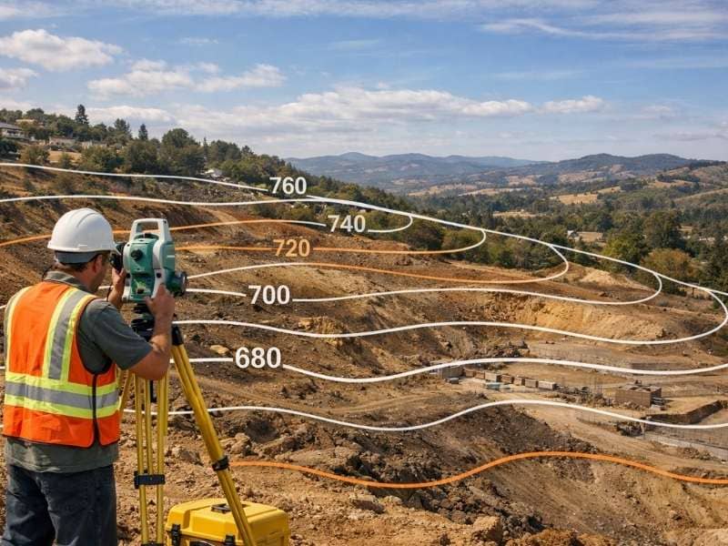
A topographic survey maps the shape of the land. It records the ground’s height, slopes, and surface features like trees, streams, and existing buildings. Builders, engineers, and architects use it to design projects that fit the land and drain water the right way. You need one before most construction, grading, or major landscaping work.
When you build on a piece of land, the shape of the ground matters as much as where the lines fall. A flat lot and a steep lot call for very different plans. A topographic survey gives your design team a clear picture of that shape before any dirt is moved.
What Does a Topographic Survey Show?
A topographic survey, often called a “topo,” focuses on the up-and-down shape of the land rather than the property lines. It captures both natural and man-made features, including slopes, hills, dips, trees, streams, fences, and existing structures. The result is a detailed map that shows what the surface really looks like.
The key feature on this map is the contour line. A contour line connects points that sit at the same height above a fixed reference level, which usually mean sea level. If you walked along a single contour line in real life, you would stay at the same height the whole way, never going up or down.
Reading these lines is simpler than it looks once you know the basic rules:
- Lines that sit close together show a steep slope, because the height changes fast over a short distance.
- Lines that spread far apart show a gentle slope or flat ground.
- Roughly circular lines usually show a hill or a peak.
- Lines never cross each other, except in rare cases like an overhanging cliff.
The space between each line is called the contour interval, and it stays the same across the whole map. Common intervals are 1, 5, 10, or 20 feet, and the value is listed in the map legend. To make reading easier, every fifth line is often drawn thicker and labeled with its height. These are called index contours.
How Do Surveyors Create One?
A licensed surveyor collects height and feature data across the whole site, then turns it into a map. To gather that data accurately, surveyors use a mix of tools:
- GPS units that pin down precise positions using satellites.
- Total stations, which measure angles and distances on the ground.
- Drones, which photograph the site from above to capture large areas quickly.
After the fieldwork, the data points are processed into the contour lines and labels you see on the finished map. Modern software can even build a 3D model of the site, so engineers can test ideas and spot problems before construction starts.
Who Uses a Topographic Survey?
Several groups rely on this survey, each for a different reason:
- Homeowners planning to build, add on, or reshape their land.
- Architects who want to design a home that sits naturally on the slope.
- Engineers who plan roads, utilities, and water flow.
- Contractors who prepare the site for grading and foundations.
Each of these professionals needs to know the true shape of the ground before they commit to a plan. Designing without it is mostly guesswork, and guesswork on a building site gets expensive fast.
When Do You Need a Topographic Survey?
You should order a topographic survey before most projects that change the land or sit on top of it. Here are the most common reasons.
Before You Build or Add On
Before any construction begins, your design team needs to understand the existing ground. The survey shows slopes, low spots, and existing features, so the building can be placed where it fits best. This is true for a new home, a large addition, or a commercial site.
To Plan Drainage and Grading
Water is one of the biggest concerns on any site. Because water always flows downhill, the elevation data shows your team exactly where it will go. They can then grade the land and plan drainage to keep water away from the foundation and prevent pooling or erosion. Getting this right early prevents serious damage later.
To Get Permits Approved
Many local governments require elevation and slope data as part of a permit application. The survey provides the proof that your project meets local rules for grading, stormwater, and drainage. Without it, your permit can be delayed or even rejected.
To Estimate Costs and Avoid Surprises
The amount of earth that must be moved depends on the real shape of the land. With accurate elevation data, your team can balance the soil that is cut away against the soil that is filled in. This leads to better cost estimates, less wasted material, and fewer expensive surprises once work begins.
How Is This Different From a Boundary Survey?
People often mix up these two surveys, but they answer different questions. A boundary survey answers “where are my property lines?” A topographic survey answers “what is the shape of my land?” One deals with legal limits, and the other deals with the physical surface.
Many building projects need both. The boundary work sets the legal edges of the lot, while the topographic work maps the terrain inside those edges. When you talk to a surveyor, you can ask whether your project calls for one or both.

 Land Surveyors are professionals who make precise measurements to determine the size and boundaries of a piece of real estate. While this is a simplistic definition, boundary surveying is one of the most common types of surveying related to home and land owners. If you fall into the following categories, please click on the appropriate link for more information on that subject: