
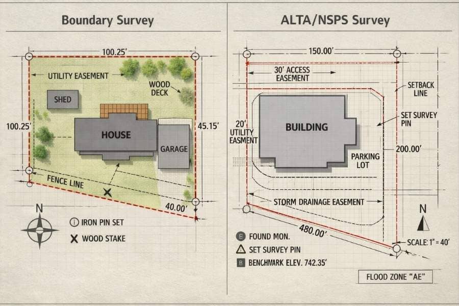
A boundary survey shows a property’s exact lines, corners, and limits, and it follows state and local rules. An ALTA/NSPS survey covers all of that, plus improvements, easements, and other items that affect the land, and it follows one national standard. Boundary surveys fit most homes. ALTA/NSPS surveys are made for commercial deals.
If you are buying property, building, or your lender just asked for “an ALTA,” you have likely run into these two terms. They sound alike, but they are not the same. Ordering the wrong one can cost you money and delay your closing.
What Is a Boundary Survey?
A boundary survey finds and marks where a property starts and ends. A licensed surveyor studies the deed and public records, measures the land on site, and places markers at the corners. It follows state and local rules, which change from place to place. It is the usual choice for homes.
A boundary survey answers one main question: where exactly are the property lines? To answer it, the surveyor does a few key things:
- Reviews the deed, recorded maps, and nearby property records.
- Measures the parcel on site and finds the existing corners.
- Sets or checks markers, such as iron rods or concrete posts, at each corner.
- Creates a drawing that shows the lines, corners, and often visible features like fences or driveways.
Because the rules are set by each state, county, or city, the exact standards can change quite a bit depending on where your property sits.
When a Boundary Survey Is Enough
A standard boundary survey usually does the job when you are:
- Buying or building a home.
- Adding a fence, pool, or room.
- Splitting a residential lot into smaller pieces.
- Settling a property line question with a neighbor.
- Checking that a project meets local setback limits.
What Is an ALTA/NSPS Land Title Survey?
An ALTA/NSPS survey is a detailed survey that includes a full boundary survey and much more. It also maps the buildings, utilities, access points, easements, and other claims that affect the land. It follows one national standard, and lenders and title companies usually require it for commercial deals.
The name comes from two groups. “ALTA” stands for the American Land Title Association. “NSPS” stands for the National Society of Professional Surveyors. Together, they set the rules this survey must follow.
The biggest feature is that national standard. Every ALTA/NSPS survey in the country meets the same baseline, called the Minimum Standard Detail Requirements. The current version is the 2026 edition, which took effect on February 23, 2026, and replaced the older 2021 rules. This sameness is helpful, because a lender in one state can trust the survey of a property in another state.
This survey also connects to the title work. The surveyor reviews the title report and shows how each listed claim, such as an easement or right-of-way, affects the parcel. That link between the survey and the title is why it is the standard for commercial closings and title insurance.
One technical point sets the current edition apart. It updated the meaning of Relative Positional Precision, a number that shows how accurately a surveyor places the property corners. The wording was made clearer so more people can understand it.
What Are Table A Items?
Every ALTA/NSPS survey has a required core, plus an optional list called Table A. These are extra items you can request to fit your deal. Common ones include:
- Building sizes and square footage.
- Zoning class and setback details.
- The location of utilities that serve the property.
- Parking space counts.
Because each Table A item adds work, it also affects the final price and the time the survey takes.
ALTA vs. Boundary Survey: The Key Differences
The main difference is scope. A boundary survey sets the property lines under state rules. An ALTA/NSPS survey adds buildings, easements, and other claims, reviews the title report, and follows one national standard. The table below shows the contrast at a glance.
| Factor | Boundary Survey | ALTA/NSPS Survey |
| Main purpose | Find property lines and corners | Support commercial deals and title insurance |
| Rules followed | State and local | One national standard |
| Detail level | Lines and corners | Lines plus buildings, easements, claims |
| Title review | No | Yes |
| Common use | Homes | Commercial property |
| Usually required by | The owner | A lender or title company |
| Cost | Lower | Higher |
| Time to finish | Faster | Longer |
Three points matter most. First is detail, since an ALTA survey maps far more than the lines alone. Second is the national standard, which keeps the work consistent across state lines. Third is the title link, because the surveyor works straight from the title report. In short, an ALTA survey is a boundary survey with much more research and detail built in.
What Affects the Price?
An ALTA/NSPS survey costs more than a boundary survey. The higher price comes from the title review, the wider fieldwork, the national standard, and any Table A items you choose. A boundary survey costs less because its scope is smaller.
Rather than guess at a number, ask for a quote based on your own property and how you plan to use it. The size, location, shape, and complexity of the parcel all play a role. For a full look at what drives surveying prices, see our guide on estimating the cost of land surveying.
Which Survey Do You Need?
Pick a boundary survey for home needs, such as buying, building, fencing, or settling a line question. Pick an ALTA/NSPS survey for commercial property, commercial loans, or any deal where a lender or title company requires it. When you are unsure, ask them, since they often set the rule.
Use these simple cases to decide:
- Buying or building a home, adding a fence, or solving a line issue points to a boundary survey.
- Buying commercial property or getting a commercial loan points to an ALTA/NSPS survey.
- Still unsure? Call a licensed surveyor and check with your lender or title company first.
Before you order, it helps to ask yourself a few questions. Does my lender or title company require an ALTA/NSPS survey? Is this property residential or commercial? Do I need claims like easements mapped, or just the lines? Are there specific Table A items my deal needs?

 FEMA’s